Best Time to Visit Havasupai Falls
As I was driving back from Sedona, I immediately began looking forward to my next adventure. I wasn’t sure what that was going to be, but I had certainly caught the bug again. I have developed more of a love for the Southwest, so that was my starting point. When I arrived home, Havasupai came to mind.

I was supposed to go to Havasupai with a hiking group many years ago, but the person I was carpooling with backed out, so I did as well since I didn’t want to drive there alone. I had opportunities to go with other groups after that, but timing never worked out. I had heard that it was getting more and more difficult to secure permits over the years and one hike group leader I know has given up on the system altogether.
Having hiked the Wave a couple of years ago, which is run by a lottery system, I know that where there is a will, there is a way. Sometimes, it’s more about timing and opportunity, so I began my research into Havasupai. I came across a Havasupai Facebook group and joined so that I could learn more about the process and experience. That group proved to be invaluable. People shared recent trip reports, links to the reservation page, weather information, personal stories and inspiration. As I perused the group’s posts, the prospect of a trip to Havasupai became more of a possibility.

One of the things I discovered from the group is that there is a transfer/cancellation list on the Havasupai tribe’s reservation site. I registered and checked the list and found that there were many permits available for October. I checked the weather and it turned out the temps were just right for day hikes and frolicking in the water. Nighttime temps seemed a bit cold for my liking, but I was encouraged by the recent trip reports where people said they didn’t freeze at night and ended up peeling off layers.
I also learned that this season is the first time Havasupai reopened to tourists after Covid had them shut down since 2020. The people who had booked reservations at that time still had those reservations honored. However, many of them had to cancel for various reasons. Let’s face it, things change after three years. Life happens, etc. and it’s hard to maintain plans for that long. That’s why there were so many permits available on the transfer list.

Some of the permits were single permits, but those were few and it seemed like they got scooped up fairly quickly. There were also permits listed in groups of two, three, four and up to six. The thing is, you have to purchase a permit as it was originally purchased. If you see a permit for four people and you only need two, you can’t just purchase two of those permits from the group. You have to purchase it as the group of four.
I had a feeling I might have to do this trip solo if I planned to go this year and I was okay with that due to posts from other solo female hikers in the Havasupai Facebook group. I asked a couple of friends anyway just to see if I could have some company, but neither of them were available. Realizing this was potentially a once in a lifetime opportunity to experience this magical place, I found and booked a solo permit two weeks before the trip date and requested the time off from work. Thankfully, I have a cool boss and she was just as excited about this trip as I was.

I had two weeks to plan and get everything together. My biggest need was a backpack. I had only been on one other backpacking trip almost 10 years ago, but I borrowed a pack from a friend who later moved away. I needed my own pack so I ordered a Viva 65 pack from Osprey. I didn’t order the pack until a little more than a week prior to my trip, but thanks to Osprey’s excellent customer service, I received my pack in two days. That gave me time to take it to my local REI and have it fitted by a specialist. Other than the pack, I pretty much had everything else except for some freeze-dried meals and snacks. I also purchased an ultralight sleeping pad from Amazon.
My biggest concerns were the nighttime temps and the fact that this was going to be my first backpacking trip post back surgery in 2020 when I wondered if I’d ever be able to hike again, let alone backpack. I had a disc that was so badly herniated that I could barely walk and had lost feeling in half of my left leg. The surgery was successful and I regained full use of my leg, but I was so afraid of being back in that predicament again that I scaled my adventures way back. Even when I started hiking again after that ordeal, I ruled out backpacking due to the weight I’d have to carry. After shedding 70 pounds of flesh over the last year, I considered backpacking again and I’m so glad I did.

I set out for Kingman on a Sunday to spend the night at the Best Western Plus. I could have stayed closer to where I was supposed to go to pick up the permits, but I had enough points for a free night stay at Best Western. It would have cost me around $200 to stay at the Hualapai Lodge in Peach Springs, which was what I had considered. Plus, Best Western had a pool and hot tub and a free hot breakfast buffet equipped with a waffle machine, my favorite.
Though it would have been nice to be able to pick up my permit the day before the hike, it was pointless to drive all that way just to drive back to Kingman for the night and then drive back out that way the next day to begin the hike. I checked out of my hotel right after an early breakfast and drove to the Grand Canyon Caverns Inn to check in and pick up my permit for the hike. From there, I drove the 60 miles to the Hilltop Parking Lot and started my hike down into the canyon at 11:30am. Most people start the hike early, even before sunrise, and I see why as it got a bit toasty on the way down. Although it was on the cooler side overall, the first two miles down were completely exposed and steep. Plus, I was carrying a 40-pound pack, so I was sweating.

I had heard reports about those first/last two miles of the hike and was a bit concerned, but more so about hiking back out and up the steep, rocky terrain. Hiking downhill was grueling and I had to stop several times to readjust my pack as it was hurting my shoulders. When I had it fitted at REI, the store associate only packed it with 15 pounds, so the fit was based on that load. I should have asked him to stuff it with 35-40 pounds for a more accurate fit. By the time I made it to camp, around 5pm, all of my leg muscles were toast and I was surprised I didn’t have a bruise on my right shoulder from the backpack’s shoulder strap.
Because I arrived to camp a little late, all the prime camping spots had been claimed. I didn’t feel like it, but I ended up walking all the way down to the end of the campground just above Mooney Falls where I found a campsite where someone had left a folding table. There were no trees around and it was pretty exposed, but there was a stunning view of the waterfall and the canyon below. I pitched my tent and set up camp. The first night was really chilly and the wind picked up. Thankfully, I staked down my tent and rainfly. The nights were gorgeous with a bright Waning Gibbous moon that illuminated the campground and canyon. I barely needed my headlamp and enjoyed using the natural light.


Prior to my trip, I had been monitoring the weather forecast for Supai, AZ, which is where Supai Village is located. The village is higher in elevation than the campground, so it tends to be cooler there. I found that the high temperature at the campground level in the canyon was 6-8 degrees warmer than what was forecasted for Supai Village, which was great for swimming in the travertine pools. I spent my first full day hiking to Beaver Falls and hung out there a bit to enjoy a swim. The trip there involved a climb down the infamous chains and ladders at Mooney Falls which wasn’t as bad as I had expected. Going back up was a little more nerve-wracking.


The hike to Beaver Falls and back was scenic with several water crossings that soothed the blisters on my feet that I acquired on the hike in the day before. I hiked solo most of the way and then caught up with a group of hikers that eventually passed. One moment of excitement came when I encountered a big horned sheep walking towards me on the trail. I noticed he wasn’t stopping, so I stepped aside and remained quiet as he calmly passed me. I had never been that close to a big horned sheep before and it was a really cool experience.


On the way back from Beaver Falls, I met two ladies from Colorado who were hiking back from the confluence. They told me they stopped and turned around about a mile before the confluence due to a herd of big horned sheep blocking the path. A hiker coming back toward them told them that one of the sheep charged another hiker up ahead, so the ladies turned around. I didn’t blame them. The ladies and I developed an instant connection and hiked back the rest of the way together. They came down to my campsite and joined me for dinner that evening and we all spent the next day exploring some of the other waterfalls including Havasu Falls where we took a swim.

The ladies joined me for dinner at my campsite the last night as we were all set to depart the next day. The evening grew cool as the sun set. However, there were these strange instances of a warm breeze that kicked up on occasion, so it was weirdly warm and cold at the same time. Certainly, there is a scientific explanation for that which probably warrants some research. As we sat eating our dinner and gazing out at the canyon to the sound of Mooney Falls, we began noticing a strange bright light illuminating the canyon walls below. We initially thought it was a spotlight from a hiker in the canyon. But as the moon rose above the rocks, it became very clear that it was the moonlight. What a treat!

After dinner, my new friends and I said our goodbyes, exchanged contact information and vowed to keep in touch. They were hiking out early the next morning while I decided to take the helicopter. My leg muscles were still in too much pain. On the bright side, my back felt great.
The next morning, I left camp at 5:30am to begin the two-mile uphill hike to Supai Village to get on the list for the helicopter. As I began the ascent out of the campground, I was even more certain I had made the right decision to take the helicopter back to the Hilltop Parking Lot. I had to wait most of the day as locals, contractors and cargo had priority, but the ride was still very much worth it. Once the helicopter lifted off, I was back at Hilltop in less than five minutes. I still felt accomplished because I did something I had never done before. I went on my first ever solo backpacking trip. If you’re on the fence about solo backpacking, this is a great introductory trip.

This was my first ever visit to Havasupai Falls and although I’ve not visited in any other month, I don’t think I’d want to go in any month but October. In my opinion, this was the perfect time as the monsoon season was over and temps were generally mild. It didn’t rain a drop the whole time I was there and the sky was cloudless until the day I hiked out when a few clouds began rolling in. As I was down in the canyon, I imagined I wouldn’t want to be there during the summer. While the water probably feels refreshing, it would be uncomfortable to sleep at night.

If you’re considering a trip to Havasupai Falls, I highly recommend planning your trip for October. Of course, the best time to go to Havasupai is whenever you can get a permit, but if you don’t mind taking a gamble with the transfer/cancellation list and have some flexibility, try booking your trip 2-3 weeks out. It’s easier to predict weather within the shorter timeframe than months out. Yes, you can look at trends, but with all the changes in weather lately, those trends could be misleading and inaccurate.
This was a magical experience and I’m so thankful I was blessed with the opportunity to live it. If you have any questions or just need some inspiration on planning your visit to Havasupai, drop me a line. I’d love to help in any way that I can.

Happy trails!
Sierra Therapy? Yes, Please!
There is something to be said about Sierra therapy. I know people flock to places like Sedona, Arizona or Utah for relaxation and peaceful excursions, but here in California, we have some exciting, yet therapeutic, destinations of our own. I recently shared a post about the vortexes in Sedona and how that visit to the desert affected me in the most positive way. I’ve been making trips to the Sierra since 2011 when I first climbed Mount Whitney and became acquainted with its restorative energy then.

This past weekend, I visited the Sierra, which I call my “Happy Place,” to check out the fall colors with a group of my friends. It was great seeing old and new faces and sharing an extraordinary experience with like-minded souls. My friend Kim and I stayed in a condo in Mammoth while our other friends stayed in Bishop. We joined everyone on a hike to Gem Lakes via the Mosquito Flat trailhead into Little Lakes Valley, just south of Mammoth and north of Bishop.

I had hiked this area a few years prior so I was somewhat familiar with the terrain. I went in late spring and the goal for that adventure was Mono Pass. However, my friends and I never made it the pass due to the amount of snow and the fact that we just weren’t feeling like exerting ourselves too much that day. We did that hike in late spring and it even started snowing on us on the way back to the cars. It wasn’t enough to stick, but it was still pretty amazing.

What made this past weekend’s hike into that same place so special was, of course, the friends I was with, but also that we hiked during a solar eclipse. We started hiking fairly early, just after 8am. With the trailhead at 10,000 feet, it was already a brisk fall morning. The sun was coming up over the mountains, but it suddenly became darker which kept the temp lower much of the way to Gem Lake. It was kind of an eerie feeling, but beautiful at the same time.

The valley was just as beautiful as I remembered it from before. The views of the mountains were expansive and majestic. The lakes were pristine, full and alive with alpine wonder. We stopped for photos at each of the many lakes we passed as each one had a unique quality of their own that set them apart. Some might say that when you’ve seen one lake, you’ve seen them all. That is not true of this place. It’s a sight that you just have to see to fully appreciate.

By the time we arrived at Gem Lake late in the morning, the eclipse was over, but the wind had really picked up and it got cold. We bundled up and took an extended break there to take pictures, have a snack and explore the lake while waiting on others in our group to arrive. There was quite a bit of snow lingering on the mountain slopes, though none of it was on the trail. There were some icy spots earlier in the hike where there was water on the trail that had frozen overnight. By afternoon, that ice had melted.

On the way back, we took the spur trail to Chickenfoot Lake. We saved that for the hike out since it was a little ways off the main trail and we didn’t want to tire ourselves out before reaching Gem Lake. Chickenfoot Lake gets its name because on a map, it’s shaped like a chicken foot. That’s not obvious while standing on the lakeshore, but it is a stunning lake. Behind Chickenfoot Lake are some hidden lakes called, you guessed it, Hidden Lakes. There is probably a trail to access those lakes, but we didn’t explore it on this hike.


Though we didn’t see very much in terms of fall colors on this hike, the experience was still greatly rewarding due to the solar eclipse, the breathtaking scenery and the camaraderie of good friends. Fall colors or not, this is an extraordinary hike in the Eastern Sierra and one of my absolute favorites.
Before heading back to the condo to prepare for dinner in Mammoth, my friend Kim and I drove the June Lake Loop to check out the fall colors there. The colors were definitely at their peak on the loop. We stopped to take some pictures at Fern Creek and then completed the loop. I wish we could have spent more time there and explored some of the lakes.


The next day, on the drive back to L.A., we stopped at McGee Creek to do a short hike and see the fall colors in the canyon. This is a very popular place for viewing fall colors and it was my first time visiting in the fall. I hiked this trail to Big McGee Lake a few years ago in the summertime and there were tons of mosquitoes. That hike is 15 miles round trip and quite a slog, but it’s a beautiful slog with an excellent payoff at the end to reward you for your hard work in getting there.

I am now convinced that fall is the best time to do this hike. The temperature was perfect and the fall colors were vibrant and alive with Sierra energy. We only hiked about three miles in as the colors began to fade the higher we ascended into the canyon. The aspens really popped with splashes of yellow and some orange. The water from McGee Creek was flowing beautifully and we spotted waterfalls everywhere. There were lots of people out admiring and photographing the colors, but the crowds thinned out further into the canyon.


After getting our fill of fall colors and photos, we got back on the 395 to return to the L.A. sprawl. I’m always sad to leave the Sierra. I really feel a deep connection to those beautiful mountains and feel homesick when I’m away for too long. John Muir said it best, “Going to the mountains is going home.” He couldn’t have been more right. Happy trails.

Exploring Sedona’s Vortexes
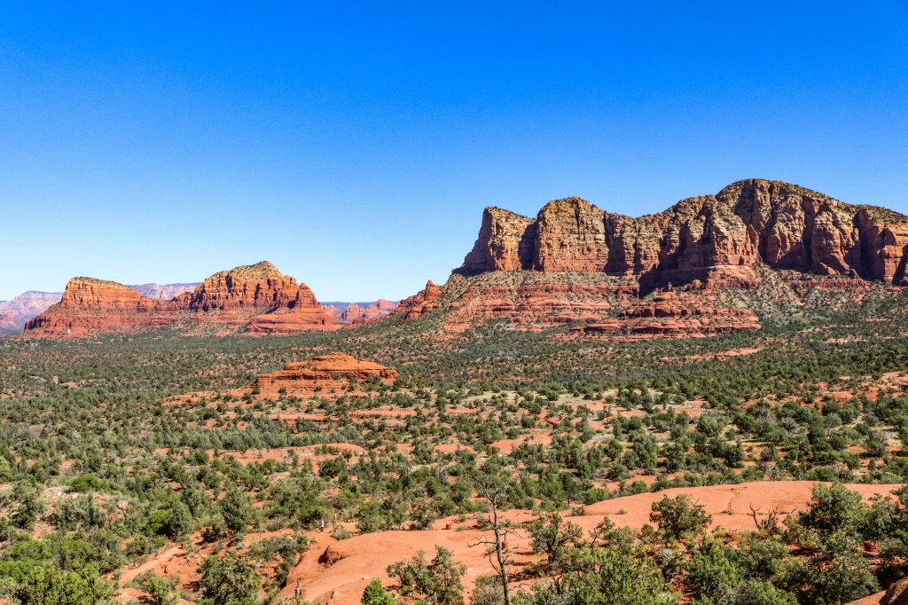
Early this summer, I had my sights set on Sedona. It had been on my radar for quite some time, and I was intrigued mainly because of the vortexes. I had read many articles about them with some people swearing by them and others not so moved, so I decided to go and investigate for myself. I set the trip for late September and made it a birthday/girl’s trip with my good friend Carrie.
So, what is a vortex? According to Visit Sedona’s website, “Sedona vortexes (the proper grammatical form ‘vortices’ is rarely used) are thought to be swirling centers of energy that are conducive to healing, meditation, and self-exploration. These are places where the earth seems especially alive with energy. Many people feel inspired, recharged, or uplifted after visiting a vortex.”
Though we had just entered the fall season, Sedona was very warm during the day, so staying hydrated was a must. With temps topping the low 90’s, the heat index made it feel much warmer, especially on challenging hikes with the sun reflecting off the red rocks. I had a full itinerary planned which included trips to four of the more popular vortexes, Bell Rock, Cathedral Rock, Airport Mesa, and Boynton Canyon.

The first hike on my itinerary was Bell Rock. Though there are several trails to access this formation, I chose the shortest route because there were other places I wanted to explore that day and I didn’t want to tire myself out. Plus, I just wanted to experience a vortex for the first time. I did the roughly 1-mile hike from the parking lot at Courthouse Vista.

The trail was well-marked most of the way, but as I ascended further, I had to find my own way. I didn’t climb to the top of Bell Rock and didn’t see anyone else doing it. When I found a nice spot with a view and no one around, I removed my pack and laid on my back to enjoy a moment of peace and solitude. The views from that spot were expansive and awe-inspiring. I could have stayed there all day.

After leaving Bell Rock, I visited the Chapel of the Holy Cross which had been high on my list of places to visit in Sedona. This was, in part, because I already had some connections there. In the weeks prior to my trip, I started following the Chapel on social media. I knew that on Wednesdays and Fridays they held mass and I sometimes tuned in to their livestream. On one day that was particularly rough for me, I saw on their post that they were taking prayer requests and asked for people to leave their requests in the comments.

I wrote my prayer request and then tuned in to the livestream of the mass. When the priest got to the prayer part of the service and mentioned my name and prayed for me, I wept. That prayer deeply touched me, and I could feel the sincerity and empathy coming through on the stream. That is what made my visit to the Chapel of the Holy Cross so much more special and endearing. While there, I spent some time in quiet reflection, lit a 3-day candle and said a prayer, then visited the gift shop and bought some gifts.

Next on the itinerary was Cathedral Rock. According to All Trails, an app that I use faithfully, this hike was rated as “Hard”. It was also supposed to have the strongest vortex energy, which is what intrigued me the most. Perhaps it was the energy of the vortex that drew me there and up that steep, challenging but well-marked path to the end of the trail and beyond. This was probably one of the hardest hikes I’ve ever done, made even more difficult by the brutal heat. Thankfully, I had lots of water, but it was no longer cold. Still, hydration is hydration.


When I reached the end of the trail sign, I noticed a ledge off to the right where people were going to take pictures, so I followed suit and had another hiker take my picture. There was a nice view on both sides of this saddle, but I was curious about the actual location of the vortex. A few text message chimes alerted me that I had cell reception, so I Googled the Cathedral Rock Vortex and discovered that it was up a steep, rocky incline to the left of where I was. I had seen people going that way but wasn’t sure what was there. I made the climb and there it was, at the location of a hidden pillar. There were only a couple of people there when I arrived, but they left shortly, and I was alone for a bit. I sat there quietly, grateful for the moment.

My last stop before meeting up with my friend Carrie at Mariposa Grill that evening was Airport Mesa, the site of another popular vortex. This was a relatively short hike, so I had the time to do it. However, when I arrived, the parking lot was full and only had space for about five or six cars to begin with. I drove down the road about a half-mile and arrived at a larger parking lot with plenty of space, but they charged a $3 fee. This parking lot was directly across from the Airport Mesa Overlook. You could hike the trail from there to the vortex, but from there it was longer, and I wasn’t quite prepared for that. I walked across the street to the overlook and took some pictures but didn’t think the view was much different from what I had already seen that day, so I didn’t linger.

On day two in Sedona, I hiked the West Fork Trail of Oak Creek Canyon. It’s not known for any vortexes, but this hike was high on my list due to all the glowing recommendations from other hikers. The pictures I had seen were enchanting, so I just had to do it. One of the notable things about this hike was the apple trees at the beginning. When I saw the first apple on the ground, I thought someone had discarded their snack. Then I saw more apples and looked up and noticed trees full of them, both green ones and red ones. I later discovered from talking to a park worker at the end of the hike that this place used to be an apple orchard and the ruins I observed just beyond the apple trees were part of it.


This mostly shaded hike was lush, green, and full of running water and life. Walking this beautiful roughly 7-mile out and back trail filled me with wonderful energy that invigorated my senses with every turn. I kept reminding myself to look up because the red canyon walls illuminated by the afternoon sun were so majestic and I felt that no matter how wide I set my camera lens, I just couldn’t completely capture the scope of all that I beheld. At times I just stood in awe, captivated by the views, sounds and scents of the canyon. As the sign at the trailhead said, this was truly the “Call of the Canyon.” I hiked all the way to the pool at the end of the canyon and it was mesmerizing. The water was clear and refreshing.

After leaving that amazing place, I drove back toward West Sedona to hike to Devil’s Bridge from the Mescal Trailhead since I had time to squeeze in another adventure before dinner that night at Elote. Though it was late in the afternoon, it was still hot, and there was minimal shade. The hike was mild initially, but the last half mile or so became more rugged and steep with a bit of a scramble just before reaching Devil’s Bridge.


The arduous, sweaty climb was rewarded with stunning scenery and the bridge was every bit as grand as it looked in the pictures I saw. From the angles of the pictures, the bridge appears narrow and scary, but I found that wasn’t the case at all. The bridge is wide, but it’s all about perspective.

On the last full day in Sedona, I hiked Boynton Canyon to the Subway and the Boynton Canyon Vortex. But first, I stopped at Sedonuts, a famous donut and coffee shop in town. I love donuts and consider myself a connoisseur, so I wanted to give them a taste test to see if the donuts really lived up to the hype. My verdict: a resounding YES! I ordered three donuts, regular glazed, a chocolate covered one and one called Cookie Monster. Each donut was fresh and pillowy soft, the perfect pick me up for my Boynton Canyon hike. The hazelnut latte I had was excellent, too.

Fueled by a sugar rush, I headed over to the Boynton Canyon trailhead where the parking lot was completely full by mid-morning. I had to park a little way down the street, but the walk wasn’t too far, and the walk was pleasant due to the good weather and scenery. The hike was moderate and there were some rocky parts, but not too steep. It was a warm day, so brought my ultralight hiking umbrella for shade, which helped a ton. Other hikers marveled at the idea and said they wished they had done the same. Keeping my pack shaded also kept my water cool in my pack, which I appreciated.


The Boynton Canyon trail gently climbed and meandered beside the Enchantment Resort, which I will have to visit at some point, perhaps during a future stay in Sedona when I really want to splurge. What I found interesting about this hike was that although the trail was very well marked, there were no signs whatsoever for the Subway Cave, even though it’s a very popular destination. The Subway Cave was the main attraction to that hike for me. There was an unmarked turnoff for the trail leading to the cave and had I not encountered another hiker at that point who directed me, I would have kept walking deeper into Boynton Canyon and totally missed it. I’m sure many hikers did miss it as it’s kind of hard to describe where the turnoff is.

The trail to the Subway Cave is well traveled but gets more rugged and steeper as the climb progresses. There are quite a few patches of shade, which provide a bit of relief from the unrelenting Arizona sun, but you must be careful. I got jabbed in the forehead by a protruding branch when I wasn’t paying attention. Though it was painful, there were no bruises, thankfully.
The remainder of the hike to the Subway Cave was uneventful until I reached the actual climb to the cave’s entrance. I had to store my cameras to use both of my hands to climb up this crack that became narrower the higher I climbed. With gravity working against me, I had to lean forward as much as possible while strategically placing my feet and hands. A year ago, I wouldn’t have even been able to fit into the little crevasse.


At the time I entered the cave, there were only a few people hanging out, so there were ample opportunities for good photos. The cave was just as I had seen it in pictures on social media and I felt so blessed to have made it there. I wasn’t sure how I was going to get down, but figured I’d address that when it was time. I took all the pictures and videos I wanted and then heard some commotion down below. I looked down and observed a huge group assembling at the base of the cave. That completely killed the peaceful vibe, so I and others fled the scene before the herd took over. Getting down wasn’t as challenging as I thought it would be. I took the marked trail to the Boynton Canyon Vortex on the return and spent a little time there before heading back to the car.

On the way back into town, I stopped at the Amitabha Stupa and Peace Park to have a look around. I had read about it and seen pictures prior to my trip and was fascinated, so I wanted to see it in person. It was serene and peaceful, up on a hill and surrounded by red rock walls with prayer flags strung from the trees. I wish I could have spent more time there to explore more of the park. It seemed expansive as there were trails leading to other points of prayer and meditation. I did a bit of research on the park and discovered that a stupa is known by Buddhists as a “Wish Fulfilling Jewel.” They consider a wish equivalent to a prayer. The stupa is said to work for people of all faiths and the park is open and welcoming to such.

Afterwards, I met back up with my friend Carrie and we went on a Pink Jeep tour which was a super fun and bumpy ride. We did the Scenic Rim/Broken Arrow combo tour, and it was one of the best off-road experiences I’d ever had. Our guide, Geoff, was knowledgeable, fun, and engaging, which made the experience that much more memorable. I highly recommend this tour if you are ever in the Sedona area. It was a great way to cap off my celebration of another trip around the sun.

One of my cousins had asked me during a conversation before this trip if I was celebrating a “milestone” birthday. I told her not necessarily but explained how I look at every birthday as a milestone. Each year that I get to make it to another birthday is cause for celebration. I’ve been through enough things in life to know that nothing is guaranteed and literally anything can happen in the blink of an eye, be it good or bad. I used to cry on every birthday, and not for good reasons. I hated the idea of growing older, not having reached the place in life I had most dreamt about and prayed for. Now, I choose to celebrate. And if any tears are shed on that special day, they are tears of joy.
As for the vortexes, I can’t honestly say whether they had any tangible effect on me or my well-being. I did everything I could to try and feel something, but I didn’t feel anything that I could directly attribute to the mystical powers of a vortex. I will say that I left Sedona feeling a lot better than I did when I first arrived. I felt more creatively inspired with a renewed spirit of hope and adventure. I felt rejuvenated in my faith and a deeper connection with God. Did the vortexes have anything to do with that? Circling back to the second paragraph of this post where it says, “Many people feel inspired, recharged, or uplifted after visiting a vortex,” I believe it’s a real possibility.

There is something remarkably special about Sedona. I can’t quite put my finger on it, but people that I encountered did seem happier and relaxed. They were very open to engaging in conversation and I even felt that some of the walls I unknowingly but habitually put up when meeting new people had come down. Maybe the vortexes had something to do with that. I encourage you to visit Sedona and embark on your own journey of self-discovery. You will undoubtedly leave a better person than when you arrived.

Last Day in Moab
The guide from the Hummer tour I went on told me about this hike down in the canyon that we overlooked on the tour. We passed the trailhead heading back from the river rafting trip and I noticed all the cars in the parking lot, so I figured it was a popular place.

In addition to the scenery of this magnificent location, what I found really fascinating about the canyon is the man who it was named after, William Grandstaff, a Black man born into slavery in the 1800s. I did a little research after the hike and came across his story. Now I feel very honored to have walked this trail. This is a fairly short 5.7-mile hike that traverses a creek numerous times and ends at a beautiful natural bridge called Morning Glory.


After hiking Grandstaff Canyon, I made a spur of the moment decision to make the 1.5-hour drive out to the Needles District of Canyonlands. I stopped at the Colorado Riverway Bridge to take some pictures first.


Canyonlands is so vast that it’s comprised of four districts: Island in the Sky (the most popular and accessible), the Needles, the Maze and the Rivers. Since Needles was the second most accessible, I deemed it worthy of a trip as I didn’t want to waste any of the remaining time that was available.

I arrived at the visitor center around 3:30pm and asked a ranger what they recommended for me to see if I only had a couple of hours to spend in the park. The ranger told me to check out the Needles viewpoint and to make sure I hiked the Cave Spring Trail which was a fairly short loop trail that passed an old cowboy camp, a spring and had two ladders to climb on the route. She had me at ladders. Instantly intrigued, I set out on the main road to check out the scenery.
I stopped at the Needles viewpoint and saw the famous Needles. There were a couple of hikes I could have done that would have brought me closer to the Needles and provided a better look, but I didn’t have enough time to do it and see the other things I wanted to see.

The next stop along the way was the Potholes, which were a little underwhelming because they were bone dry, but still sort of cool to view. I wanted to see them because the brochure featured this glowing picture of the potholes filled with water and a rainbow arched above it. I knew I wouldn’t see the rainbow, but from the picture, I was expecting the potholes to be like small lakes. That wasn’t the case at all.
After leaving the Potholes, I continued down the road to the end where there was a 10-mile hiking trail called the Confluence. I certainly didn’t have time to hike that, so I just took pictures of the area from the end of the road. The trail veered down into a canyon.


On the way to the Cave Spring Trail, I stopped at the Wooden Shoe Arch viewpoint and took some pictures, then went for the last adventure of the day. The Cave Spring hike was so much fun and I enjoyed climbing the professionally installed ladders. It’s a fun, short hike and a must-do for anyone visiting the Needles District of Canyonlands. I’d like to return to Needles and spend at least two days there to explore more of that beautiful, enchanting place.
Adventures of the Arches
After hiking through the Fiery Furnace, I visited the iconic Delicate Arch, a short(ish) hike that packed a bit of a punch and reminded me of the hike to Enchanted Rock in Texas.

The next stops were Balanced Rock and the Garden of Eden, which piqued my interest because of the name. I didn’t understand the whole Garden of Eden reference, but the rocks were really neat. I rounded out this section of the park exploring the Windows section which also featured Double Arch.


For the last adventure of the day, I hiked to Landscape Arch via Devil’s Garden. The trail continues on past Landscape Arch and turns into a primitive trail with rocky slopes and steep drop-offs. However, I had already hiked a total of 12 miles by this point and the sun was setting, so I kept it simple. Devil’s Garden is beautiful and the trail to Landscape Arch and back is pretty mild.


The venture through Devil’s Garden to Landscape Arwas the perfect walk to cap off a spectacular day.
Hiking the Fiery Furnace
I had a 7am entry ticket to get into Arches and had gotten a permit to hike the Fiery Furnace, so I set out early for the adventure to beat the crowds and the heat. First, I had to stop at the Visitor Center to pick up the hiking permit and attend the 20-minute orientation.


I had read about this hike during my initial research into visiting Arches and was immediately intrigued. Though it’s not easy to get a permit, if you plan accordingly, you can get one. It’s not like getting a permit for Whitney or the Wave which are both run by a lottery system. The park only issues 75 permits per day and you can either do the hike as self-guided exploration or do the ranger-led version. I chose the self-guided hike.


The Fiery Furnace is basically a labyrinth. There are lots of dead ends, which are usually marked, but not all of them are. Some of the dead ends lead to cool arches. There are arrows on the trail, but they are not always obvious. During the orientation, the Ranger said that the arrows were not really intended for hikers, but for new rangers in training. He challenged us to see how many arrows we could spot. It was almost like a scavenger hunt, which was fun.


The ranger also said GPS devices hardly work inside the Fiery Furnace, but I found my All Trails map to be pretty reliable and helpful. I had a great time exploring all the twists, turns and shimmying through various tight squeezes. It was a full body workout scrambling up and down the rocks trying to navigate through all the passageways.


I’ve heard of people getting lost or disoriented in the Fiery Furnace, but I didn’t find it much of a challenge to reach the exit. There were several other people exploring the maze with the same idea as me to start early, so I never felt isolated. There was also a ranger-led group not far from me. At times, I leap-frogged the group when I took time to explore some of the dead ends. This adventure was a fabulous introduction to Arches National Park and I highly recommend it. You can get a permit by visiting recreation.gov and searching “Fiery Furnace.”
PowerStep orthotic insoles are defined by its Podiatrist-designed arch support. PowerStep was developed as an affordable pain relief solution for people suffering from all foot conditions. That’s why Powerstep is the #1 Podiatrist recommended insole. PowerStep changed the game for me when I was dealing with a long, painful bout of plantar fasciitis. I know they will do the same for you. Use my code, TRAILS15, to get 15% off your purchase.
Ultimate Sea Cave Kayaking Adventure
What better way to spend Labor Day Weekend than to visit one of America’s lesser visited national parks? Located about 20 miles off the coast of Ventura Harbor, Santa Cruz Island of Channel Islands National Park is only accessible by boat and the ride can be anywhere from 1-1.5 hours long, depending on the conditions and wildlife sightings. Although this national park doesn’t charge an entrance fee, there is a fee to take the ferry to the island. Contact Island Packers for more information on that.

I was alerted to this Ultimate Sea Cave Kayaking Adventure via a post on Instagram. I don’t remember who posted it. I follow so many travel and adventure pages and see a variety of things popping up in my newsfeed on a daily basis. When I came across this tour I looked it up and when I read that it went to Potato Harbor, I knew I had to sign up. I had only hiked to the overlook above Potato Harbor before this trip. There is no access to the harbor from that overlook, so I was excited for the opportunity to see it up close and in person.
Although I wanted to partake of this adventure badly, I wasn’t 100% sure I was up for it. The write up on Santa Barbara Adventure Company’s website said that for this particular tour, you needed to be an intermediate to advanced kayaker and able to kayak 4-5 miles. While not a beginner, and certainly not advanced, I felt comfortable classifying myself at the low end of intermediate. I mean, I had kayaked before and even did one of their sea cave adventures a few years ago. Just not the ultimate version. I didn’t even complete the shorter tour I did with them because I overheated in the wetsuit I was wearing. I was also 70+ pounds heavier at the time.

All I could think about was being with a large group of kayakers who were a lot more fit and faster than me while I brought up the tail and held everyone up. When I arrived on the island for orientation and met Zack, the tour guide, I quickly realized none of my fears were going to materialize. It was just me and one other person with Zack and the rest of the crowd of people who ferried across the sea from Ventura were either on other kayak tours, kayaking on their own, or just visiting the island to hike or camp. I felt much less intimidated and Zack made us feel very comfortable.

After a brief safety and instructional talk, we got suited up with life vests and helmets and headed toward our kayaks. We each had our own kayak, which is what I prefer as it’s easier to steer. The water was a little choppy so it took me a little while to get acclimated. I had kayaked a couple of months ago in the harbor where the water was flat. Sea kayaking is quite different. To give me some time to acclimate, Zack clipped me to his kayak and towed me until we reached the first cave at Elephant Rock.

After clearing that first cave, we all felt more confident and paddling on the choppy water became easier. We explored many caves on our way to Potato Harbor, some requiring flashlights as we kayaked deeper into the chambers. We even paddled further out to sea as we spotted a pod of dolphins and wanted to get a closer look. It turned out they were farther out than we cared to venture and we still had some distance to cover, so we turned back and continued skirting the island.


The further around we went, the calmer the wind and waves became. Suddenly, the water was clear with a magical turquoise hue. We observed other wildlife including cormorants, pelicans and sea lions. Zack kept us entertained with jokes and stories along the way. As we paddled along, Zack asked us how we came to be so adventurous. The other kayaker said he grew up camping and doing fun, outdoorsy things with his family as a kid and grew to love it, so he caught the adventure bug at an early age.
When Zack turned to me, my answer surprised him when I shared that I was very sheltered as a child and didn’t get out much at all. I certainly never went hiking or camping as my family didn’t take interest in those things. I caught the adventure bug later after moving to California as an adult. Maybe this is always who I was, but I just needed to be in the right environment for that seed in me to sprout.


The sun greeted us once we reached Potato Harbor. It had been overcast most of the way there with a few sprinkles at one point. I was grateful for the sunlight as I wanted to take a dip in the pristine waters and explore some of the marine life beneath the surface. After beaching our kayaks, we ate lunch and then donned our snorkel gear for some underwater exploration. The water was cold, but I was able to tolerate it without a wetsuit for a little while. One thing I should have worn was my life vest, which I left at the kayak. The water was salty enough to keep me buoyant without it. However, I did low-key panic once I could no longer touch the bottom.


We spent a little more time taking in the sights of Potato Harbor and appreciating the somewhat exclusivity of our visit, then got back into our kayaks for the sunny and peaceful journey back to Scorpion Ranch. At the end of the tour, I felt so accomplished and happy with myself for venturing out on this extraordinary adventure. Sometimes, we can defeat ourselves in our minds before we even give something a try. I’m so glad I did this in spite of the negative thoughts floating through my head. I really surprised myself and I hope my story encourages you to step out on an adventure of your own where you prove to yourself that you can do something amazing, too.

My Time on the Central Coast
I drove back from San Simeon along the coast since I knew I’d be driving back in the storm. Since the weather was good much of the way, I took a leisurely pace and made some stops along the way.


My first stop was to check out the surf at the beach. I took a walk along the boardwalk to see how far it went and then turned around when I reached the road, which wasn’t too far. After that, I backtracked and went under the bridge to the beach.


After that, I stopped in Morro Bay and ate lunch at The Galley which was highly recommended. There were lots of people milling about enjoying a beautiful Sunday afternoon. I observed several people kayaking and boating on the water as well.


I didn’t get into the rain until I was passing through Santa Ynez about 30 miles from Santa Barbara. I was driving through Ventura around the time the earthquake hit near Ojai, which is not far away from there. However, I didn’t feel it. The car must have some really good suspension.

The rain became pretty intense as I drove further east on the 101, but thankfully, there wasn’t a lot of traffic on the road. By the time I got home, it was really pouring, but I was happy to have made it back safely. It was a great weekend.
Hollywood at Hearst Castle
When I first visited Hearst Castle sometime in 2013, it was an captivating experience. I was in awe of the architecture of the castle, the rooms and its rich history. The thing that stood out the most was the Neptune Pool. I loved the Roman influences of the columns and statues and the pool itself looked so inviting. However, no one was allowed to get too close, and we certainly weren’t allowed to take a dip. Bummer.

I love pools. As a matter of fact, when I’m looking to book a hotel, if I see that it doesn’t have a nice pool, I will bypass it, even if I’m not planning to swim. I guess I’m a bit of a pool snob. I’d rather call myself a pool aficionado. Some of my favorite pools are in Las Vegas at the Bellagio. They have several and what I love the most is the Roman architecture displayed throughout the grounds. It makes me feel like I’m on vacation in Italy.
Of all the pools I’ve had the pleasure of swimming in, the Neptune Pool at Hearst Castle is hands down the best for more reasons than its stunning Roman architecture. Hearst Castle was the home of American businessman William Randolph Hearst who was known for founding the nation’s largest newspaper chain and media company, Hearst Communications.
In Hearst Castle’s golden days of the 1920s and 1930s, these lush grounds were frequented by celebrity guests such as Charlie Chaplin, Cary Grant, Joan Crawford, the Marx Brothers and Winston Churchill, to name a few. Being that Charlie Chaplin is my absolute favorite actor of the silent film era, it was such a privilege to be a guest at a Hollywood-themed party in a place that he himself partied. I felt similarly awestruck when I visited Charlie Chaplin’s home in Switzerland in 2017, now known as Chaplin’s World.

The evening started at the Hearst Castle Visitor Center where all the guests to this party of 50 attendees checked in. It felt so special having my name on such a list, almost like being a guest of the legendary William Randolph Hearst himself.


We boarded the bus that took us to the top of the hill where Hearst Castle sits overlooking San Simeon and the vast, deep blue Pacific Ocean. The bus dropped us off at the front near the steps that led right to the Neptune Pool. There, we were given a brief orientation by the Foundation at Hearst Castle’s Executive Director, Mitch Massey, and Ranger Mullins of the California State Parks.

After the orientation, we were free to go change in the historic dressing rooms or head straight to the pool. I had to change, so I went into one of the dressing rooms. As I walked in, I felt like I had stepped back into time, to the Roaring 20s. Every detail of that time period has been carefully preserved, including the lighting. After changing into my retro swimsuit, I had to snap a picture in the mirror because I certainly looked the part.


I left the dressing room and walked down to the pool. I was given a towel that I was able to keep as a souvenir. Upbeat tunes were playing from the bands of the 1920s and 30s and the mood was very festive. There were various vendors set up and serving cocktails, wine, beer and both savory and sweet culinary delights. I bypassed the food and drinks and went straight for the pool, easing into it initially because I thought the water might be freezing. The water felt great. It was probably 10-15 degrees warmer up on the hill than down in San Simeon and I was grateful for that.


I floated around in a pool donut that one of the lifeguards brought me for a couple of hours. Then I got out to try some of the food and drinks. Everything was outstanding from the presentation to the flavor. I loved the non-alcoholic wine from NON as well as the alcoholic cocktails served by Paso Robles Distillery Trail. I would be remiss to not mention the dreamy gelato offered by Leo Leo Gelato. It reminded me of the gelato I had in Italy. The food catered by Brick and Mortar Catering Company was absolutely delicious.


As the sun began its final descent on this memorable evening, the outside temperature took a dip. Interestingly, it was warmer in the pool than it was outside it. The chilly air didn’t ruin one of the most spectacular sunsets I had ever seen. The night sky gave way to an impressive light show in the distance due to the approaching tropical storm that was quite a way off from the area and not expected to have much of an impact there. It was like fireworks capping off a most enchanting evening.

